Massive processing tasks completed in the Forest Carbon Monitoring project in Forestry TEP
You may remember the Forest Carbon Monitoring project that was presented in a news item last year. This project aims to set up and pilot a prototype of a forest biomass and carbon monitoring system that meets the requirements of different forestry stakeholder groups. Forestry TEP is used as the processing platform. The project has now reached a stage of data pre-processing for the large area demonstrations to be conducted later this year. For the past two months, massive Sentinel-1 and Sentinel-2 pre-processing tasks have been successfully run on Forestry TEP.
The GAMMA Remote Sensing commercial Sentinel-1 pre-processing software package was implemented on the Forestry TEP platform. This software was used to pre-process all Sentinel-1A dual-polarization (VV/VH) IWS mode observations over Europe for 2020 and 2021. The pre-processing used ground-range projected images of the SAR backscatter intensity as input and resulted in a stack of terrain geocoded, radiometrically calibrated and co-registered Sentinel-1 observations for the two years. Over 50 000 images were processed, at best with 30 virtual machines running 60 concurrent jobs. The effective CPU time used totaled over 50 000 hours. The processing was conducted successfully and finished ahead of the planned time. These datasets are used as input in the BIOMASAR approach to create two European wide growing stock volume and biomass maps in the European demonstration.
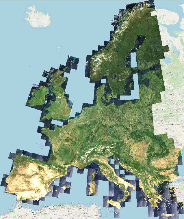
For the Sentinel-2 pre-processing, Terramonitor implemented their cloud free image compositing algorithm to the Forestry TEP platform. This algorithm was used to create two multi-temporal composite image mosaics over Europe for 2020 and 2021, both covering 744 Sentinel-2 tiles. For each tile, imagery from the 15th June to 15th September were used, except for areas north of 62° N, where only images from 15th June onwards were used. The compositing algorithm evaluated each pixel according to four criteria: cloudiness, resemblance to usual pixels observed in the location (based on a reference mosaic), haze and shadows. A weight was then given for each pixel according to the four criteria. These weights were used to average the observations given as input in production of the final image. The resulting cloud free mosaics over Europe will be used in the European demonstration of the Forest Carbon Monitoring project to detect changes between 2020 and 2021 with the Autochange algorithm.
The AFRY Smart Forestry team and VTT are currently working to implement and modify the processing services and pipelines in Forestry TEP for the continental and other demonstrations. The goal is to start the Forest Carbon Monitoring project demonstrations in July.