Arbonaut using F-TEP to monitor land use
It happens quite often that you hear the claim that in our era of science and technology, the common man lives amid an overwhelming information flow. With satellites and space technology, we no longer have white areas on the map, in the same way as there was for great explorers some few hundred years ago. While this is all true, there is still lots of work to be done in tracking the surface of our planet. In particular, one of the most ambitious applications in remote sensing is to estimate land use and its change over time. This has huge value for industries like forestry and agriculture. While in the Western world you often have means like laser scanning or established land surveying to help in interpretation work, large part of the World – almost all of the tropics – still rely heavily on satellite images.
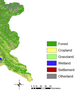
Arbonaut has been working for years with innovative solutions for international forestry and land use mapping in tropical countries. Within REDD+, Arbonaut has been calculating carbon baselines, i.e. the amount of carbon stored in forests over the last 15- 20 years. As the timeline backwards has been rather long, the available images have been acquired using older technology. But we now live in interesting times! The European Space Agency (ESA) has recently introduced satellites with very detailed capacity for object identification, including global coverage 10 m spatial resolution radar satellites (Sentinel-1). This is particularly exciting because radar beam correlates with object shape rather than colour, and by combining these two characteristics we can better separate land use class. This is exactly what we have been testing at Arbonaut: we have used a combination of optical and radar satellite to first rule out certain classes, for example build-up environment which correlates well with radar but in optical image looks much like barren ground. This kind of step-by-step process filters out some very distinct land use types, after which it is easier to separate forest from grassland and cropland.
Along with new data, one of the biggest benefits in our work has come from moving it partly over to the Forestry Thematic Exploitation Platform (F-TEP). Traditionally the processing work in remote sensing includes searching, downloading, pre-processing and mosaicking individual images to obtain country-level mosaics. Now we run all this in an online computing environment without having to download anything locally. F-TEP also provides very useful products: the radar scientists in VTT have developed time-stacked image derivatives that stabilize the otherwise varying signal. Incorporating these new datasets with our previous algorithms and the new computing environment has led to better results and with much less effort and time. In future, we hope we can run also the accuracy assessment and quality control of the results in the cloud environment.
Arbonaut Team