Forestry TEP services providing satellite-based data to Wuudis forest management solution
One of the greatest benefits of online processing platforms like Forestry TEP (F-TEP) is their connectivity to other online systems used in forest management, enabling efficient and fast cooperation between platforms over the internet.
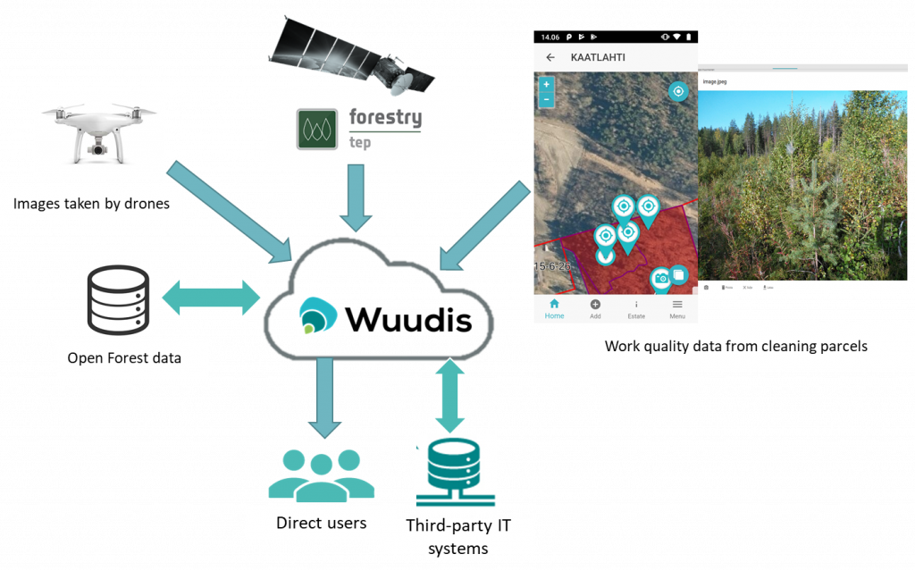
Wuudis Solutions Oy offers software solutions for forest management and bioenergy supply chain and logistics. It integrates open software technology with years of field experience in forestry business. Portal and mobile solutions and field work management are its core business. The two services of Wuudis Solutions, Wuudis Business and Wuudis Bioenergy, turn digitalization, forest management and bio business into a single value chain solution. Wuudis services are based on internet cloud-technology, so they are quick and easy to implement and can be integrated to existing IT systems through standard interfaces. All features can be used from computers, tablets and smart phones, as well as offline. The services are scalable, and currently available in over 10 language versions. They use open Street, Google and WMS (WebMapService) terrain Maps, including a drawing tool for additional features on the map, and GPS and photo information when using mobile application in the field. Wuudis platform utilizes national and local forest-resource data, and transfer information about performed silviculture activities, such as reforestation, cleaning of seedlings or different harvesting operations (pre-commercial thinning, selected harvesting, open felling etc.) back to the authority system/3rd party database.
Wuudis exploits the power of forest big-data, including satellite data, field operational data coming from Wuudis app, forest open data and forest management plans. The Web Map Service (WMS) interface enabled in F-TEP allows efficient transfer of value-added information from F-TEP to the Wuudis environment. The EO based products from F-TEP services can be seamlessly used together with data derived from other sources such as drone flights and on-the-ground forest inventories.
VTT has implemented the Probability services for forest structural parameter estimation in F-TEP. These services utilize Sentinel-2 data and field sample plots to estimate forest structural parameters (like stem count, volume, diameter, basal area and height) in a spatially explicit manner in 10 m resolution. These data are valuable input for the Wuudis modelling processes and visualization. The forest parameter maps can be generated in the F-TEP environment and transferred to Wuudis either in GeoTIFF or polygon formats (like the Finnish Forest Information Standard XML or the globally recognized GeoJSON) for further use.
Technically, the connection to F-TEP has been tested and verified to enable smooth cooperation. We are currently evaluating the most suitable business opportunities for the service chain as more and more viable opportunities for integrated use of platforms are emerging in the forestry and bioenergy sectors.
Wuudis Team